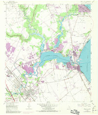
1955 Map of League City
USGS Topo · Published 1970About this map
The coastal interface of Galveston Bay and Clear Lake reveals a landscape in transition, where established settlements like Seabrook and Kemah meet the industrial footprints of the Clear Lake Oil Field. The 1969 photorevisions highlight suburban expansion across Harris Co and Galveston Co, visible in the developing residential patterns at Glen Cove and Clear Lake Shores.
Find a feature on this map
47 named features on this map. Tap any name to fly to it.
Don’t see what you’re looking for? This feature index may not catch every label — zoom into the map to look around manually.
Map Details
Editions of this 1955 League City Map
Other maps of this area

1915 · Deepwater
USGS Topo · 1:24,000

1916 · Genoa
USGS Topo · 1:24,000

1916 · Morgan Point
USGS Topo · 1:24,000

1916 · Seabrook
USGS Topo · 1:24,000

1916 · La Porte
USGS Topo · 1:24,000

1919 · Morgan Point
USGS Topo · 1:31,680

1919 · Deepwater
USGS Topo · 1:31,680

1920 · Seabrook
USGS Topo · 1:31,680

1920 · Genoa
USGS Topo · 1:31,680

1920 · La Porte
USGS Topo · 1:31,680