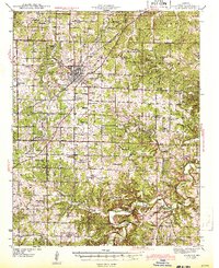
1943 Map of Lebanon
USGS Topo · Published 1943About this map
The St Louis and San Francisco railroad anchors the local economy of this Ozark plateau region, connecting the hub of Lebanon to the wider world during the early 1940s. A dense network of rural one-room schoolhouses and country churches, such as Kapp Sch, Mt Olivette Ch, and Hazel Dell Sch, reveals the community structure of outlying townships like Aug Laize and Osage.
Find a feature on this map
87 named features on this map. Tap any name to fly to it.
Don’t see what you’re looking for? This feature index may not catch every label — zoom into the map to look around manually.
Map Details
Editions of this 1943 Lebanon Map
2 editions found

Other maps of this area

1931 · Manes
USGS Topo · 1:48,000

1933 · Stoutland
USGS Topo · 1:62,500

1934 · Macks Creek
USGS Topo · 1:48,000

1938 · Stoutland
USGS Topo · 1:62,500

1939 · Macks Creek
USGS Topo · 1:62,500

1939 · Long Lane
USGS Topo · 1:62,500

1941 · Manes
USGS Topo · 1:62,500

1941 · Lebanon
USGS Topo · 1:62,500

1942 · Long Lane
USGS Topo · 1:62,500

1943 · Richland
USGS Topo · 1:62,500