
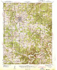
1943 Map of Lebanon
USGS Topo · Published 1943About this map
Lebanon serves as the central hub of this 1941 survey, where the St Louis San Francisco railroad and nascent aviation infrastructure at Lebanon Airport intersect with a landscape defined by sinkholes and river forks. The Laclede County terrain is marked by geological curiosities like Silver Mine Sink, Howell Cave, and Saltpeter Cave, reflecting the karst topography common to this region of the Ozarks. Rural life is meticulously documented through an extensive network of schoolhouses and country churches, such as Bear Thicket Sch and Hough Chapel, many associated with family-named landmarks like Singleton Ridge and Roper Cem. The Osage Fork and Gasconade River provide the primary drainage, winding through a patchwork of small communities including Orla, Morgan, and Oakland. This survey captures the transition from a traditional agrarian economy to a more modern transit network as the Second World War began.
Find a feature on this map
88 named features on this map. Tap any name to fly to it.
Don’t see what you’re looking for? This feature index may not catch every label — zoom into the map to look around manually.
Map Details
Editions of this 1943 Lebanon Map
2 editions found
Other maps of this area

1931 · Manes
USGS Topo · 1:48,000

1933 · Stoutland
USGS Topo · 1:62,500

1934 · Macks Creek
USGS Topo · 1:48,000

1938 · Stoutland
USGS Topo · 1:62,500

1939 · Macks Creek
USGS Topo · 1:62,500

1939 · Long Lane
USGS Topo · 1:62,500

1941 · Manes
USGS Topo · 1:62,500

1941 · Lebanon
USGS Topo · 1:62,500

1942 · Long Lane
USGS Topo · 1:62,500

1943 · Richland
USGS Topo · 1:62,500