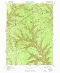
1947 Map of Lee Fire Tower
USGS Topo · Published 1977About this map
The Lee Fire Tower watches over a deeply dissected landscape at the convergence of Potter, Lycoming, and Tioga counties. This rugged interior of the Pennsylvania Wilds is defined by high plateau ridges like Kettle Ridge and Chestnut Ridge, separated by a dense network of hollows including Indian Bill Hollow and Frying Pan Run. The map illustrates a wilderness economy transitioning from early industry to resource management, evidenced by Sliders Dam and Big Dam along the watercourses, and a solitary Gas Well in the Elk district.
Find a feature on this map
97 named features on this map. Tap any name to fly to it.
Don’t see what you’re looking for? This feature index may not catch every label — zoom into the map to look around manually.
Map Details
Editions of this 1947 Lee Fire Tower Map
5 editions found

Other maps of this area

1937 · Waterville
USGS Topo · 1:48,000

1943 · Hyner
USGS Topo · 1:62,500

1943 · Waterville
USGS Topo · 1:62,500

1946 · Young Womans Creek
USGS Topo · 1:24,000

1946 · Tiadaghton
USGS Topo · 1:24,000

1946 · Antrim
USGS Topo · 1:62,500

1946 · Renovo East
USGS Topo · 1:62,500

1946 · Cedar Run
USGS Topo · 1:24,000

1946 · Slate Run
USGS Topo · 1:24,000

1947 · Galeton
USGS Topo · 1:62,500