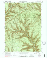
1947 Map of Lee Fire Tower
USGS Topo · Published 1988About this map
Lee Fire Tower anchors this high-elevation landscape where the borders of Potter, Tioga, and Lycoming counties meet. Historically defined by its timber and watershed management, the terrain is carved by deep hollows like Prying Pan Hollow and Indian Bill Hollow, leading down to major waterways such as Kettle Creek and Francis Branch. This 1947 survey shows a region deeply integrated with forest maintenance and transport, evidenced by the extensive network of fire roads and trails including the Brackman Trail and Cushman Trail. A small Clay Mine and a remote Landing Strip near Francis Fork suggest a mix of natural resource extraction and early aviation access in this isolated stretch of the Commonwealth. The presence of the Fill Trestle Trail points toward the area's logging railroad heritage, where infrastructure was built to span the sharp drainage of Slate Run.
Find a feature on this map
59 named features on this map. Tap any name to fly to it.
Don’t see what you’re looking for? This feature index may not catch every label — zoom into the map to look around manually.
Map Details
Editions of this 1947 Lee Fire Tower Map
5 editions found

Other maps of this area

1937 · Waterville
USGS Topo · 1:48,000

1943 · Hyner
USGS Topo · 1:62,500

1943 · Waterville
USGS Topo · 1:62,500

1946 · Young Womans Creek
USGS Topo · 1:24,000

1946 · Tiadaghton
USGS Topo · 1:24,000

1946 · Antrim
USGS Topo · 1:62,500

1946 · Renovo East
USGS Topo · 1:62,500

1946 · Cedar Run
USGS Topo · 1:24,000

1946 · Slate Run
USGS Topo · 1:24,000

1947 · Galeton
USGS Topo · 1:62,500