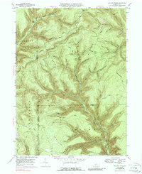
1947 Map of Lee Fire Tower
USGS Topo · Published 1988About this map
The rugged topography of the Pennsylvania northern tier is deeply etched into this 1947 landscape, where the Lee Fire Tower stands as a primary sentinel over the heavily wooded plateau. High ridges like Cushman Ridge and Chestnut Ridge define the steep-sided valleys of Kettle Creek and Slate Run. The map reveals a specialized upland economy dependent on forestry and isolation, evidenced by a network of logging roads and paths such as Cushman Road, Brackman Trail, and Apple Tree Trail. A curious Landing Strip is positioned on the high ground near the Potter and Lycoming county line, reflecting mid-century utility in a region otherwise dominated by mountain drainage like Indian Bill Run and Francis Fork. The placement of Sliders Dam on the upper reaches of Cherry Run suggests early water management or industrial remnants within these remote forest districts.
Find a feature on this map
71 named features on this map. Tap any name to fly to it.
Don’t see what you’re looking for? This feature index may not catch every label — zoom into the map to look around manually.
Map Details
Editions of this 1947 Lee Fire Tower Map
5 editions found

Other maps of this area

1937 · Waterville
USGS Topo · 1:48,000

1943 · Hyner
USGS Topo · 1:62,500

1943 · Waterville
USGS Topo · 1:62,500

1946 · Young Womans Creek
USGS Topo · 1:24,000

1946 · Tiadaghton
USGS Topo · 1:24,000

1946 · Antrim
USGS Topo · 1:62,500

1946 · Renovo East
USGS Topo · 1:62,500

1946 · Cedar Run
USGS Topo · 1:24,000

1946 · Slate Run
USGS Topo · 1:24,000

1947 · Galeton
USGS Topo · 1:62,500