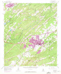
1959 Map of Leeds
USGS Topo · Published 1971About this map
Industrial expansion and rugged topography converge at Leeds, where the Cahaba River winds through narrow valleys defined by Blackjack Ridge and Oak Mountain. By the late 1950s, the region was a complex network of resource extraction and transit, evidenced by numerous mines, a quarry, and various shale pits supporting local brick manufacturing at the brick kilns near Lovick. The map documents a corridor of heavy rail transit including the Southern Railway and the Seaboard Coast Line, which pierce the ridges via the Roper Tunnel and Oak Mountain Tunnel.
Find a feature on this map
75 named features on this map. Tap any name to fly to it.
Don’t see what you’re looking for? This feature index may not catch every label — zoom into the map to look around manually.
Map Details
Editions of this 1959 Leeds Map
4 editions found
Other maps of this area

1889 · Springville
USGS Topo · 1:125,000

1889 · Birmingham
USGS Topo · 1:125,000

1890 · Bessemer
USGS Topo · 1:125,000

1890 · Talladega
USGS Topo · 1:125,000

1892 · Birmingham
USGS Topo · 1:125,000

1892 · Springville
USGS Topo · 1:125,000

1892 · Talladega
USGS Topo · 1:125,000

1892 · Bessemer
USGS Topo · 1:125,000

1895 · Birmingham
USGS Topo · 1:125,000

1905 · Leeds
USGS Topo · 1:62,500