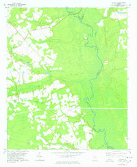
1978 Map of Leefield
USGS Topo · Published 1978About this map
The Ogeechee River carves a wide swampy path along the border of Bulloch and Effingham Counties, defining the eastern edge of this rural landscape. Situated in the coastal plain of Georgia, the area around Leefield is characterized by its agricultural fields and pine forests, interconnected by historical routes like River Road. A significant corridor of local history is marked by the Old Railroad Grade, which once facilitated the transport of timber and farm goods through the region.
Find a feature on this map
18 named features on this map. Tap any name to fly to it.
Don’t see what you’re looking for? This feature index may not catch every label — zoom into the map to look around manually.
Map Details
Editions of this 1978 Leefield Map
This is the sole edition of this map. No revisions or reprints were ever made.
Other maps of this area

1918 · Oliver
USGS Topo · 1:62,500

1919 · Shirley
USGS Topo · 1:62,500

1919 · Egypt
USGS Topo · 1:62,500

1920 · Oliver
USGS Topo · 1:62,500

1921 · Brooklet
USGS Topo · 1:62,500

1939 · Egypt
USGS Topo · 1:62,500

1943 · Brooklet
USGS Topo · 1:62,500

1943 · Egypt
USGS Topo · 1:62,500

1943 · Shirley
USGS Topo · 1:62,500

1943 · Millen
USGS Topo · 1:125,000