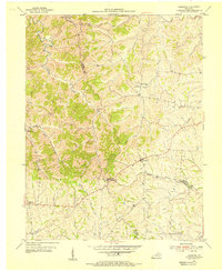
1954 Map of Leesburg
USGS Topo · Published 1955About this map
The rolling Bluegrass hills of central Kentucky are defined here by a network of rural hamlets and parish churches at the intersection of Harrison, Scott, and Bourbon counties. Leesburg and Oxford serve as the primary focal points of this 1950s agricultural landscape, where the terrain is carved by the winding Little Eagle Creek and the southern flow of Silas Creek. Local history is deeply embedded in the land, from the Hinton Cem and Sharon Cem to community anchors like Beards Ch and Gilead Ch. Small clusters of homes and outbuildings at Lees Lick and Davis suggest a pattern of decentralized settlement typical of the era's farming economy. The map also records early infrastructure and natural crossings, such as Muddy Ford along the Little Eagle Creek, providing a detailed look at the rural connections that linked these highland farms to nearby market towns.
Find a feature on this map
27 named features on this map. Tap any name to fly to it.
Don’t see what you’re looking for? This feature index may not catch every label — zoom into the map to look around manually.
Map Details
Editions of this 1954 Leesburg Map
3 editions found
Other maps of this area

1906 · Georgetown
USGS Topo · 1:62,500

1908 · Georgetown
USGS Topo · 1:62,500

1927 · Lexington
USGS Topo · 1:48,000

1929 · Cynthiana
USGS Topo · 1:48,000

1929 · Lexington
USGS Topo · 1:62,500

1934 · Cynthiana
USGS Topo · 1:62,500

1939 · Sadieville
USGS Topo · 1:62,500

1953 · Sadieville
USGS Topo · 1:24,000

1953 · Breckinridge
USGS Topo · 1:24,000
1953 · Cynthiana
USGS Topo · 1:24,000