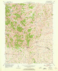
1954 Map of Leesburg
USGS Topo · Published 1973About this map
Leesburg and the surrounding farmland of central Kentucky sit at the intersection of Scott, Harrison, and Bourbon Counties in this mid-century topographic survey. The landscape is defined by the winding course of Eagle Creek and its many tributaries, such as Straight Fork and Little Mill Creek. Small settlements like Oxford and Davis serve as local anchors, connected by a network of rural roads that bypass the steeper hills for the creek bottoms.
Find a feature on this map
25 named features on this map. Tap any name to fly to it.
Don’t see what you’re looking for? This feature index may not catch every label — zoom into the map to look around manually.
Map Details
Editions of this 1954 Leesburg Map
3 editions found
Other maps of this area

1906 · Georgetown
USGS Topo · 1:62,500

1908 · Georgetown
USGS Topo · 1:62,500

1927 · Lexington
USGS Topo · 1:48,000

1929 · Cynthiana
USGS Topo · 1:48,000

1929 · Lexington
USGS Topo · 1:62,500

1934 · Cynthiana
USGS Topo · 1:62,500

1939 · Sadieville
USGS Topo · 1:62,500

1953 · Sadieville
USGS Topo · 1:24,000

1953 · Breckinridge
USGS Topo · 1:24,000
1953 · Cynthiana
USGS Topo · 1:24,000