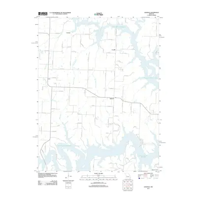
2011 Map of Leesville
USGS Topo · Published 2011About this map
Harry S Truman Reservoir dominates the drainage and topography of this Henry County landscape, where winding backwaters and fingers of the lake reach deep into the Missouri countryside. Small settlements like Leesville and the uniquely named Tightwad serve as local anchors in an area defined by rural road networks and agricultural tracts. The map reveals the hydrology of several significant tributaries, including Cedar Creek, White Oak Creek, and Sparrow Creek, which feed into the primary reservoir system. To the west, the community of Coal and the northern site of Hortense mark the periphery of this lake-oriented region. This 2011 survey captures the area at a point when the reservoir had become the central geographical feature, influencing the local layout of rural roads such as NE Highway PP and SE 500th Rd.
Find a feature on this map
71 named features on this map. Tap any name to fly to it.
Don’t see what you’re looking for? This feature index may not catch every label — zoom into the map to look around manually.
Map Details
Editions of this 2011 Leesville Map
This is the sole edition of this map. No revisions or reprints were ever made.
Other maps of this area

1887 · Clinton
USGS Topo · 1:125,000

1887 · Warsaw
USGS Topo · 1:125,000

1894 · Warsaw
USGS Topo · 1:125,000

1894 · Clinton
USGS Topo · 1:125,000

1936 · Shawnee Bend
USGS Topo · 1:24,000

1941 · Valhalla
USGS Topo · 1:24,000

1941 · Lowry City
USGS Topo · 1:24,000

1945 · Fristoe
USGS Topo · 1:62,500

1945 · Lowry City
USGS Topo · 1:24,000
1945 · Valhalla
USGS Topo · 1:24,000