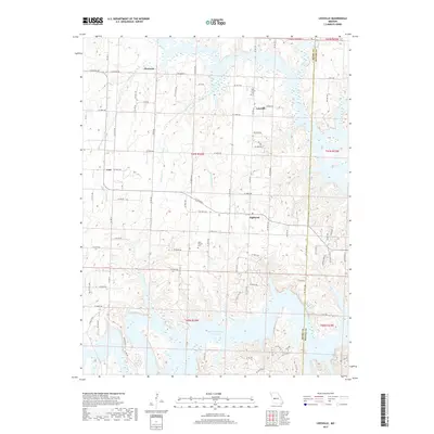
2017 Map of Leesville
USGS Topo · Published 2017About this map
The Harry S Truman Reservoir dominates the southern landscape of this Missouri quadrangle, where the rolling hills of Henry County meet the rising waters of the Grand River system. The small community of Leesville sits near the headwaters of these intricate inlets, serving as a focal point alongside other local settlements such as Hortense, Coal, and the uniquely named Tightwad. The area's rural character is defined by a dense network of country roads, including SE 200th Rd and NE Hwy PP, which connect scattered homesteads and historic sites. Genealogists will find significance in the documentation of the Tebo Church Cem and Parks Chapel Cem. Numerous waterways like White Oak Cr and Mound Springs Cr carve through the terrain, illustrating the complex drainage patterns that feed into the reservoir's expansive reach across the Henry and Benton County lines.
Find a feature on this map
86 named features on this map. Tap any name to fly to it.
Don’t see what you’re looking for? This feature index may not catch every label — zoom into the map to look around manually.
Map Details
Editions of this 2017 Leesville Map
This is the sole edition of this map. No revisions or reprints were ever made.
Other maps of this area

1887 · Clinton
USGS Topo · 1:125,000

1887 · Warsaw
USGS Topo · 1:125,000

1894 · Warsaw
USGS Topo · 1:125,000

1894 · Clinton
USGS Topo · 1:125,000

1936 · Shawnee Bend
USGS Topo · 1:24,000

1941 · Valhalla
USGS Topo · 1:24,000

1941 · Lowry City
USGS Topo · 1:24,000

1945 · Fristoe
USGS Topo · 1:62,500

1945 · Lowry City
USGS Topo · 1:24,000
1945 · Valhalla
USGS Topo · 1:24,000