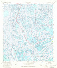
1957 Map of Leesville
USGS Topo · Published 1965About this map
The coastal marshlands of Leeville anchor this mid-century coastal survey, where the terrestrial landscape begins to yield to the Gulf of Mexico. Bisected by the prominent channel of Bayou Lafourche, the area is a complex network of wetlands and tidal waters, including Hackberry Bay and Timbalier Bay. Settlement is concentrated along the narrow natural levee of the bayou, following the path of La 1.
Find a feature on this map
25 named features on this map. Tap any name to fly to it.
Don’t see what you’re looking for? This feature index may not catch every label — zoom into the map to look around manually.
Map Details
Editions of this 1957 Leesville Map
3 editions found
Other maps of this area

1941 · Leesville
USGS Topo · 1:62,500

1941 · Slagle
USGS Topo · 1:62,500

1942 · Florien
USGS Topo · 1:62,500

1942 · Kisatchie
USGS Topo · 1:62,500

1943 · Leesville
USGS Topo · 1:62,500

1943 · Kisatchie
USGS Topo · 1:62,500

1944 · Florien
USGS Topo · 1:62,500

1944 · Slagle
USGS Topo · 1:62,500

1946 · Leesville
USGS Topo · 1:62,500

1948 · Leesville
USGS Topo · 1:62,500