1955 Map of Leeton
USGS Topo · Published 1982About this map
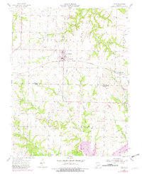
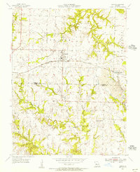
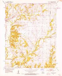
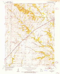
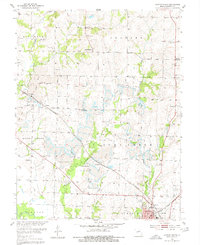
Leeton serves as the central hub of this Missouri landscape, situated where the St Louis Southwestern Railroad intersects with local roads at the boundary of Post Oak and Jefferson townships. The map documents a transition in local industry and infrastructure, noting both the active Strip Mine in the east and segments of an Old Railroad Grade near New Castle. The terrain is deeply carved by drainage systems including Mineral Creek, Little Tebo Creek, and Coon Creek, which dictate the placement of early rural institutions. Genealogists will find a high density of burial sites and houses of worship scattered across the township lines, such as Hickory Grove Ch and its associated Hickory Grove Cem, alongside the Sanctified Ch and Pleasant View Sch. These markers of community life, along with several family-named plots like Avery Cem and Lewis Cem, provide a detailed record of the mid-century social geography of Johnson and Henry counties.
Find a feature on this map
30 named features on this map. Tap any name to fly to it.
Don’t see what you’re looking for? This feature index may not catch every label — zoom into the map to look around manually.
Map Details
Editions of this 1955 Leeton Map
2 editions found
Other maps of this area

1885 · Warrensburg
USGS Topo · 1:125,000

1887 · Clinton
USGS Topo · 1:125,000

1887 · Warrensburg
USGS Topo · 1:125,000

1894 · Warrensburg
USGS Topo · 1:125,000

1894 · Clinton
USGS Topo · 1:125,000

1947 · Jefferson City
USGS Topo · 1:250,000
1953 · Calhoun East
USGS Topo · 1:24,000
1953 · Calhoun West
USGS Topo · 1:24,000
1953 · Clinton North
USGS Topo · 1:24,000

1954 · Jefferson City
USGS Topo · 1:250,000