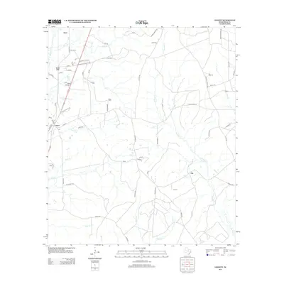
2013 Map of Leggett
USGS Topo · Published 2013About this map
The small community of Seven Oaks anchors this portion of Polk County, where residential clusters are often named after major Texas cities like Odessa, Albany, and Lubbock. This pattern of naming local streets and sub-settlements suggests a mid-century development style transposed onto the rural landscape. The terrain is defined by a dense network of tributaries including Big Sandy Cr and Menard Cr, which drain the timbered lands surrounding Leggett and Ollie.
Find a feature on this map
78 named features on this map. Tap any name to fly to it.
Don’t see what you’re looking for? This feature index may not catch every label — zoom into the map to look around manually.
Map Details
Editions of this 2013 Leggett Map
This is the sole edition of this map. No revisions or reprints were ever made.
Other maps of this area

1954 · Beaumont
USGS Topo · 1:250,000

1955 · Camden
USGS Topo · 1:62,500

1955 · New Willard
USGS Topo · 1:62,500

1957 · Beaumont
USGS Topo · 1:250,000

1958 · Livingston
USGS Topo · 1:62,500

1958 · Segno
USGS Topo · 1:62,500

1984 · Hortense
USGS Topo · 1:24,000

1984 · Soda
USGS Topo · 1:24,000

1984 · Beaumont
USGS Topo · 1:250,000
1984 · Livingston
USGS Topo · 1:24,000