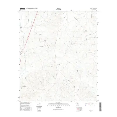
2016 Map of Leggett
USGS Topo · Published 2016About this map
Big Sandy Creek and its many tributaries, including Menard Creek and Alexander Creek, dominate this part of Polk County, carving a network of drainages through the East Texas piney woods. Small communities such as Leggett and Seven Oaks anchor the western edge of the territory along the main highway corridor. The landscape is dotted with several family and community burial grounds, such as Carrington Cemetery and Pine Ridge Cemetery, which serve as vital markers for genealogical research in this rural timber region. Local transit is defined by a dense web of county roads and loops, including Sanders Loop, Baskin Loop, and Oakdale Loop, winding between topographic features like Red Hollow. The settlement of Ollie sits further east, connected to the primary settlements by Upper Leggett Road and FM 942, reflecting the enduring rural character of the county.
Find a feature on this map
57 named features on this map. Tap any name to fly to it.
Don’t see what you’re looking for? This feature index may not catch every label — zoom into the map to look around manually.
Map Details
Editions of this 2016 Leggett Map
This is the sole edition of this map. No revisions or reprints were ever made.
Other maps of this area

1954 · Beaumont
USGS Topo · 1:250,000

1955 · Camden
USGS Topo · 1:62,500

1955 · New Willard
USGS Topo · 1:62,500

1957 · Beaumont
USGS Topo · 1:250,000

1958 · Livingston
USGS Topo · 1:62,500

1958 · Segno
USGS Topo · 1:62,500

1984 · Hortense
USGS Topo · 1:24,000

1984 · Soda
USGS Topo · 1:24,000

1984 · Beaumont
USGS Topo · 1:250,000
1984 · Livingston
USGS Topo · 1:24,000