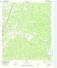
1984 Map of Leggett
USGS Topo · Published 1984About this map
The Southern Pacific railroad corridor anchors the western edge of this East Texas timber and oil landscape, connecting the small communities of Leggett and Seven Oaks. This mid-1980s data highlights a deep-rooted rural infrastructure, marked by a high concentration of family and community burial grounds such as Carrington Cem, Oats Cem, Rice Cem, and Pine Ridge Cem. These sites, alongside Providence Ch and the Crossroads Cem, provide significant touchpoints for genealogical research in this part of Polk County.
Find a feature on this map
29 named features on this map. Tap any name to fly to it.
Don’t see what you’re looking for? This feature index may not catch every label — zoom into the map to look around manually.
Map Details
Editions of this 1984 Leggett Map
This is the sole edition of this map. No revisions or reprints were ever made.
Other maps of this area

1954 · Beaumont
USGS Topo · 1:250,000

1955 · Camden
USGS Topo · 1:62,500

1955 · New Willard
USGS Topo · 1:62,500

1957 · Beaumont
USGS Topo · 1:250,000

1958 · Livingston
USGS Topo · 1:62,500

1958 · Segno
USGS Topo · 1:62,500

1984 · Hortense
USGS Topo · 1:24,000

1984 · Soda
USGS Topo · 1:24,000

1984 · Beaumont
USGS Topo · 1:250,000
1984 · Livingston
USGS Topo · 1:24,000