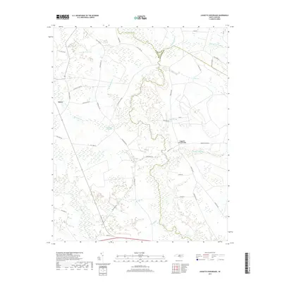
2019 Map of Leggetts Crossroads
USGS Topo · Published 2019About this map
The borderlands of Martin and Beaufort counties are defined here by a dense network of black-water drainage systems, where Tranters Cr and Grindle Creek weave through a landscape of named pocosons and wetlands. The settlement at Leggetts Crossroads and the village of Stokes anchor the area's rural road network, which follows the higher ground between expansive lowlands like Bear Grass Swamp and Horsepen Swamp. This 2019 survey documents a region still heavily influenced by its hydrology, where local history is etched into the landscape at Sheppard Millpond and along numerous creeks like Great Br Meadow Br. The layout of local thoroughfares, including Sheppard Mill Rd and State Rd 1414, reveals how modern transit continues to navigate around the extensive natural basins of Turkey Swamp and Briery Swamp, preserving the traditional agrarian and wilderness character of the North Carolina coastal plain.
Find a feature on this map
41 named features on this map. Tap any name to fly to it.
Don’t see what you’re looking for? This feature index may not catch every label — zoom into the map to look around manually.
Map Details
Editions of this 2019 Leggetts Crossroads Map
This is the sole edition of this map. No revisions or reprints were ever made.
Other maps of this area

1901 · Parmele
USGS Topo · 1:62,500

1901 · Williamston
USGS Topo · 1:62,500

1902 · Williamston
USGS Topo · 1:62,500

1902 · Parmele
USGS Topo · 1:62,500

1903 · Winterville
USGS Topo · 1:62,500

1903 · Chocowinity
USGS Topo · 1:62,500

1905 · Chocowinity
USGS Topo · 1:62,500

1905 · Winterville
USGS Topo · 1:62,500

1951 · Washington
USGS Topo · 1:24,000

1953 · Rocky Mount
USGS Topo · 1:250,000