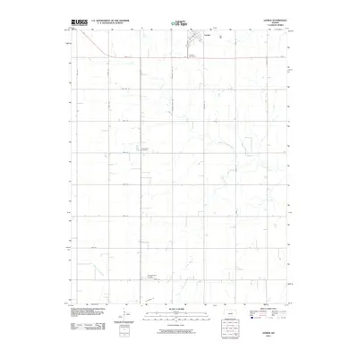
2010 Map of Lehigh
USGS Topo · Published 2010About this map
Lehigh anchors the northern edge of this Marion County landscape, situated where the grid of modern section roads meets the legacy of earlier transit. The town's surroundings are defined by a network of local watercourses, including the South Cottonwood River and the meandering path of Stony Brook. Genealogists will find several significant burial sites across the township, most notably the Alexanderwohl Friedhof Cemetery in the south and the Springfield Cemetery further north. The presence of Chisholm Trail Rd serves as a geographic nod to the area's history as a corridor for movement across the Kansas plains. To the southwest, Middle Emma Creek cuts through the agricultural plots, illustrating the drainage patterns that have long dictated the placement of farmsteads and the orientation of routes like Old Hwy 56.
Find a feature on this map
24 named features on this map. Tap any name to fly to it.
Don’t see what you’re looking for? This feature index may not catch every label — zoom into the map to look around manually.
Map Details
Editions of this 2010 Lehigh Map
This is the sole edition of this map. No revisions or reprints were ever made.
Other maps of this area

1889 · Newton
USGS Topo · 1:125,000

1894 · Newton
USGS Topo · 1:125,000

1955 · Hutchinson
USGS Topo · 1:250,000

1957 · Peabody NW
USGS Topo · 1:24,000

1959 · Hutchinson
USGS Topo · 1:250,000

1965 · Goessel
USGS Topo · 1:24,000
1965 · Hesston
USGS Topo · 1:24,000

1971 · Durham
USGS Topo · 1:24,000
1971 · Lehigh
USGS Topo · 1:24,000
1971 · Waldeck
USGS Topo · 1:24,000