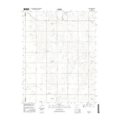
2015 Map of Lehigh
USGS Topo · Published 2015About this map
The Cottonwood River and its southern branch, the S Cottonwood River, define the rural landscape of western Marion County. This agricultural region is punctuated by the settlements of Lehigh in the north and Goessel along the southern border. The terrain is deeply tied to the historical movement of cattle and commerce, evidenced by the path of the N Chisholm Trl and Chisholm Trail Rd cutting through the center of the township lines. Local history and genealogy are anchored by several community landmarks, including the Lehigh Mennonite Cem and the Alexanderwohl (Fried of) Cem. Smaller waterways like Stony Brook and Middle Emma Cr snake through the grid of section lines, which are formally designated by a system of rural routes such as Alamo Rd and Diamond Rd.
Find a feature on this map
33 named features on this map. Tap any name to fly to it.
Don’t see what you’re looking for? This feature index may not catch every label — zoom into the map to look around manually.
Map Details
Editions of this 2015 Lehigh Map
This is the sole edition of this map. No revisions or reprints were ever made.
Other maps of this area

1889 · Newton
USGS Topo · 1:125,000

1894 · Newton
USGS Topo · 1:125,000

1955 · Hutchinson
USGS Topo · 1:250,000

1957 · Peabody NW
USGS Topo · 1:24,000

1959 · Hutchinson
USGS Topo · 1:250,000

1965 · Goessel
USGS Topo · 1:24,000
1965 · Hesston
USGS Topo · 1:24,000

1971 · Durham
USGS Topo · 1:24,000
1971 · Lehigh
USGS Topo · 1:24,000
1971 · Waldeck
USGS Topo · 1:24,000