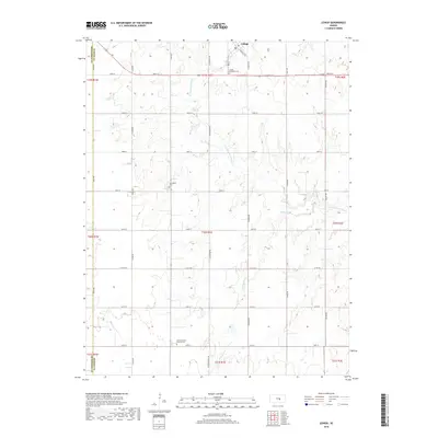
2018 Map of Lehigh
USGS Topo · Published 2018About this map
The small city of Lehigh anchors the northern edge of this Kansas landscape, situated near the headwaters of the S Cottonwood River. This region of Marion County is characterized by a grid of rural section roads and a strong presence of early community heritage, evidenced by sites like the Lehigh Mennonite Cem and Springfield Cem. To the south, the Alexanderwohl Fried of Cem serves as a significant marker of local genealogical history. The map traces the winding paths of several smaller waterways, including Stony Brook and Middle Emma Cr, which cut through the agricultural sections. A notable historic corridor is preserved in the naming of N Chisholm Trl and Chisholm Trail Rd, indicating the area's role in the historic cattle-driving routes that once moved through the central plains.
Find a feature on this map
35 named features on this map. Tap any name to fly to it.
Don’t see what you’re looking for? This feature index may not catch every label — zoom into the map to look around manually.
Map Details
Editions of this 2018 Lehigh Map
This is the sole edition of this map. No revisions or reprints were ever made.
Other maps of this area

1889 · Newton
USGS Topo · 1:125,000

1894 · Newton
USGS Topo · 1:125,000

1955 · Hutchinson
USGS Topo · 1:250,000

1957 · Peabody NW
USGS Topo · 1:24,000

1959 · Hutchinson
USGS Topo · 1:250,000

1965 · Goessel
USGS Topo · 1:24,000
1965 · Hesston
USGS Topo · 1:24,000

1971 · Durham
USGS Topo · 1:24,000
1971 · Lehigh
USGS Topo · 1:24,000
1971 · Waldeck
USGS Topo · 1:24,000