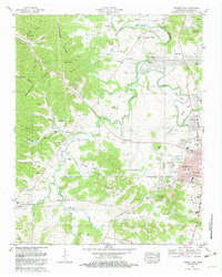
1981 Map of Leipers Fork
USGS Topo · Published 1988About this map
The Harpeth River carves a winding path through this portion of Williamson County, defining the landscape between the burgeoning outskirts of Franklin and the historic village of Leipers Fork. By the early 1980s, the terrain shows a mix of traditional agriculture and emerging residential developments such as Cottonwood Estates and Battlewood Estates. A dense concentration of family and community burial sites, including McGavock Cem, Vaughn-King Cem, and several locations identified simply as Slave Cem, provides significant genealogical data points. Along the western edge, Backbone Ridge rises above a series of named hollows like Birdsong Hollow and Poorhouse Hollow, while the Louisville and Nashville corridor and the Jackson Highway facilitate transit through the river valley. Landmarks such as the Battle Ground Academy and Jim Warren Park anchor the eastern edge of the survey area.
Find a feature on this map
110 named features on this map. Tap any name to fly to it.
Don’t see what you’re looking for? This feature index may not catch every label — zoom into the map to look around manually.
Map Details
Editions of this 1981 Leipers Fork Map
3 editions found
Other maps of this area

1901 · Colombia
USGS Topo · 1:125,000

1903 · Nashville
USGS Topo · 1:125,000

1909 · Franklin
USGS Topo · 1:62,500

1930 · White Bluff
USGS Topo · 1:62,500

1932 · Nashville
USGS Topo · 1:62,500

1933 · White Bluff
USGS Topo · 1:62,500

1936 · Spring Hill
USGS Topo · 1:24,000

1936 · Theta
USGS Topo · 1:24,000

1936 · Bethesda
USGS Topo · 1:24,000

1946 · Leipers Fork
USGS Topo · 1:24,000