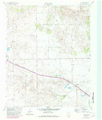
1962 Map of Lelia Lake
USGS Topo · Published 1982About this map
Lelia Lake sits at the heart of this Donley County landscape, where the FT Worth and Denver railroad cuts a diagonal line across the plains. This 1960s era survey, updated with revisions from the late 1970s, captures a rural environment defined by its water sources and transportation links. To the north, the Salt Fork Red River and Saddlers Creek carve into the terrain, while the settlement itself is surrounded by smaller water bodies like Cattail Lake and Taylor Lakes.
Find a feature on this map
16 named features on this map. Tap any name to fly to it.
Don’t see what you’re looking for? This feature index may not catch every label — zoom into the map to look around manually.
Map Details
Editions of this 1962 Lelia Lake Map
2 editions found
Other maps of this area

1954 · Amarillo
USGS Topo · 1:250,000

1954 · Plainview
USGS Topo · 1:250,000

1958 · Amarillo
USGS Topo · 1:250,000

1958 · Plainview
USGS Topo · 1:250,000

1959 · Lelia Lake Creek
USGS Topo · 1:24,000

1959 · Troublesome Creek
USGS Topo · 1:24,000

1962 · Lelia Lake
USGS Topo · 1:24,000

1962 · Roach Ranch
USGS Topo · 1:24,000

1962 · Griffin Ranch
USGS Topo · 1:24,000

1963 · Hedley
USGS Topo · 1:24,000