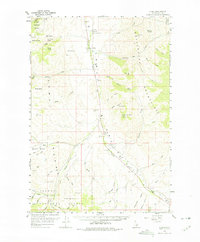
1956 Map of Lemhi
USGS Topo · Published 1975About this map
The Fort Lemhi Monument and Sacajawea Monument stand as central landmarks in this mid-century survey of the Lemhi Valley. The landscape is defined by the Lemhi River corridor, which serves as the primary axis for settlement and travel, connecting the small communities of Tendoy and Lemhi. This valley floor is hemmed in by the formidable Beaverhead Mountains to the east and the Salmon National Forest to the west, creating a corridor of high-altitude ranching and historical commemoration.
Find a feature on this map
76 named features on this map. Tap any name to fly to it.
Don’t see what you’re looking for? This feature index may not catch every label — zoom into the map to look around manually.
Map Details
Editions of this 1956 Lemhi Map
3 editions found
Other maps of this area

1950 · Salmon
USGS Topo · 1:62,500

1951 · Salmon
USGS Topo · 1:62,500

1955 · Dubois
USGS Topo · 1:250,000

1955 · Dillon
USGS Topo · 1:250,000

1956 · Leadore
USGS Topo · 1:62,500

1956 · Patterson
USGS Topo · 1:62,500

1956 · May
USGS Topo · 1:62,500

1956 · Goldstone Mtn
USGS Topo · 1:62,500

1956 · Lemhi
USGS Topo · 1:62,500

1957 · Dillon
USGS Topo · 1:250,000