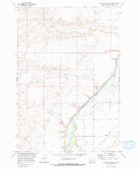
1969 Map of Lemonade Springs
USGS Topo · Published 1973About this map
Lemonade Springs and the surrounding high country of Big Horn County are captured here in the late 1960s, showing a landscape defined by its vital water sources. The Bighorn River flows through the southeastern portion of the map, supported by an intricate network of irrigation infrastructure including the Big Horn Canal and the Soap Creek Ditch. These human-engineered waterways contrast with the natural drainage of Beauvais Creek and the South Fork Hay Coulee, which carve through the terrain. The presence of a Cem and a Gravel Pit near the river suggests small, localized pockets of activity within this wide-open territory, while a prominent Pipeline cutting across the southwestern corner indicates the region's role in energy transport during this era.
Find a feature on this map
11 named features on this map. Tap any name to fly to it.
Don’t see what you’re looking for? This feature index may not catch every label — zoom into the map to look around manually.
Map Details
Editions of this 1969 Lemonade Springs Map
This is the sole edition of this map. No revisions or reprints were ever made.
Other maps of this area

1894 · St. Xavier
USGS Topo · 1:125,000

1894 · Fort Custer
USGS Topo · 1:125,000

1901 · St. Xavier
USGS Topo · 1:125,000

1915 · Spenceville
USGS Topo · 1:31,680

1954 · Hardin
USGS Topo · 1:250,000

1957 · Hardin
USGS Topo · 1:250,000

1958 · Hardin
USGS Topo · 1:250,000

1960 · St Xavier
USGS Topo · 1:24,000

1960 · Mission Coulee
USGS Topo · 1:24,000

1960 · Hardin SW
USGS Topo · 1:24,000