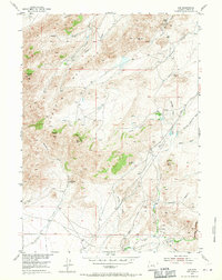
1953 Map of Leo
USGS Topo · Published 1971About this map
Pedro Mountains dominate this 1953 landscape in Carbon County, where high-elevation ranching and rugged topography define the land use. The map reveals a sparse network of isolated outposts, including Peters Ranch and Indian Grove Ranch, connected by primitive routes like Kortz Road. Evidence of shifting habitation is clear at Combs Ranch (Aband), reflecting the difficulty of maintaining permanent settlements in this high-plains environment. The terrain is deeply incised by numerous seasonal drainages such as Galusha Draw and Gooseberry Creek, which flow around prominent landmarks like Pyramid Peak and The Chimneys. Surveyed as part of the Department of the Interior’s program for the Missouri River Basin development, the map details a region where water sources like Indian Springs were critical to the survival of the early sheep and cattle operations documented here.
Find a feature on this map
28 named features on this map. Tap any name to fly to it.
Don’t see what you’re looking for? This feature index may not catch every label — zoom into the map to look around manually.
Map Details
Editions of this 1953 Leo Map
3 editions found
Other maps of this area

1951 · Pathfinder Reservoir NW
USGS Topo · 1:24,000

1951 · Bear Spring
USGS Topo · 1:24,000

1951 · Pathfinder Dam
USGS Topo · 1:24,000

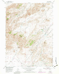
1953 · Leo
USGS Topo · 1:24,000

1953 · Seminoe Dam NE
USGS Topo · 1:24,000

1953 · Seminoe Dam
USGS Topo · 1:24,000

1953 · Pathfinder Reservoir SW
USGS Topo · 1:24,000

1953 · Fourmile Ridge
USGS Topo · 1:24,000

1953 · Beaver Creek
USGS Topo · 1:24,000

1955 · Casper
USGS Topo · 1:250,000