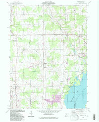
1994 Map of Leon
USGS Topo · Published 1997About this map
The agricultural lands of eastern Ashtabula County and the border of Pennsylvania are defined here by the headwaters of the East Branch Ashtabula River and West Branch Ashtabula River. This mid-century landscape, updated through the 1990s, reveals a persistent grid of rural routes like Schrambling Road and Ayers Road, connecting scattered crossroads settlements. Local heritage is concentrated at Richmond Center, where the Richmond Sch and Richmond Cem sit near the geographical heart of the township. To the southeast, the terrain shifts as the land meets the waters of Pymatuning Lake and the Shenango River. This area includes the Pymatuning State Park shoreline and small residential clusters such as Padanaram and Padan, providing a detailed look at the recreational and residential development along the reservoir's edge during the late 20th century.
Find a feature on this map
45 named features on this map. Tap any name to fly to it.
Don’t see what you’re looking for? This feature index may not catch every label — zoom into the map to look around manually.
Map Details
Editions of this 1994 Leon Map
This is the sole edition of this map. No revisions or reprints were ever made.
Other maps of this area

1900 · Girard
USGS Topo · 1:62,500

1905 · Andover
USGS Topo · 1:48,000

1906 · Conneaut
USGS Topo · 1:62,500

1906 · Linesville
USGS Topo · 1:62,500

1907 · Andover
USGS Topo · 1:62,500

1908 · Linesville
USGS Topo · 1:62,500

1950 · Cleveland
USGS Topo · 1:250,000

1956 · Cleveland
USGS Topo · 1:250,000

1959 · Hartstown
USGS Topo · 1:24,000

1959 · Beaver Center
USGS Topo · 1:24,000