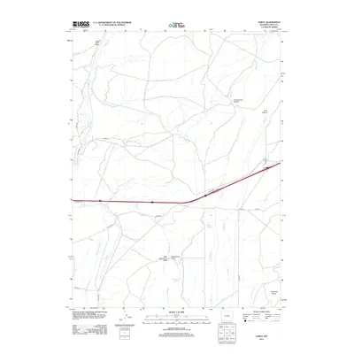
2012 Map of Leroy
USGS Topo · Published 2012About this map
Coal Mine Draw marks the northern reaches of this high-altitude Uinta County landscape, where the terrain is defined by a network of drainage systems and historical water management. The area is characterized by deep hollows and draws, such as Cottonwood Hollow and Rock Hollow, which feed into major watercourses like Muddy Cr and Spring Cr. Evidence of early 21st-century agricultural infrastructure is prominent through the inclusion of the Byrne Ditch Number 2 and Oasis Ditch, essential for ranching in this arid environment. The map captures a high-desert plateau punctuated by significant landmarks like Sugarloaf Butte and natural water sources including Bigelow Springs and Musselman Springs. The Interstate 80 corridor serves as the primary modern thoroughfare, cutting through the southern half of the quadrangle while intersecting local routes like French Rd and Bigelow Rd.
Find a feature on this map
30 named features on this map. Tap any name to fly to it.
Don’t see what you’re looking for? This feature index may not catch every label — zoom into the map to look around manually.
Map Details
Editions of this 2012 Leroy Map
This is the sole edition of this map. No revisions or reprints were ever made.
Other maps of this area

1954 · Ogden
USGS Topo · 1:250,000

1958 · Ogden
USGS Topo · 1:250,000

1960 · Ogden
USGS Topo · 1:250,000

1964 · Fort Bridger
USGS Topo · 1:24,000

1964 · Carter
USGS Topo · 1:24,000
1964 · Robertson
USGS Topo · 1:24,000

1965 · Bridger
USGS Topo · 1:24,000

1965 · Ragan
USGS Topo · 1:24,000

1965 · Leroy
USGS Topo · 1:24,000

1965 · Meadow Draw
USGS Topo · 1:24,000