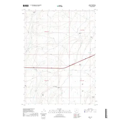
2017 Map of Leroy
USGS Topo · Published 2017About this map
Leroy sits at the northwestern edge of this Uinta County landscape, where the high desert terrain is defined by a sophisticated network of water management features and named draws. The reliance on seasonal and spring water is evident in the presence of Oasis Ditch, Byrne Ditch Number 2, and Bigelow Bench Reservoir, which support life and agriculture in this arid environment. Significant natural landmarks like Sugarloaf Butte and Meyers Ridge rise above the drainage systems of Muddy Cr and Spring Cr. The nomenclature of the land reflects both its geology and human history, from the resource-hinting Coal Mine Draw and Soda Hollow to the family-named Musselman Springs. Transportation through this corner of Wyoming is dominated by the modern path of Interstate 80, which cuts across the Bigelow Bench, following the easier grades between the region’s many draws and hollows.
Find a feature on this map
38 named features on this map. Tap any name to fly to it.
Don’t see what you’re looking for? This feature index may not catch every label — zoom into the map to look around manually.
Map Details
Editions of this 2017 Leroy Map
This is the sole edition of this map. No revisions or reprints were ever made.
Other maps of this area

1954 · Ogden
USGS Topo · 1:250,000

1958 · Ogden
USGS Topo · 1:250,000

1960 · Ogden
USGS Topo · 1:250,000

1964 · Fort Bridger
USGS Topo · 1:24,000

1964 · Carter
USGS Topo · 1:24,000
1964 · Robertson
USGS Topo · 1:24,000

1965 · Bridger
USGS Topo · 1:24,000

1965 · Ragan
USGS Topo · 1:24,000

1965 · Leroy
USGS Topo · 1:24,000

1965 · Meadow Draw
USGS Topo · 1:24,000