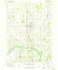
1970 Map of Leslie
USGS Topo · Published 1973About this map
The Grand River winds through the southern portion of this 1970 landscape, creating a wetland corridor that separates the township of Rives from Tompkins. This area is defined by its early 1970s rural character, centered on the village of Leslie and the nearby crossroads of Rives Junction. The Old Penn Central Railroad serves as a primary north-south artery, cutting past Teaspoon Hill and the settlement of North Leslie.
Find a feature on this map
43 named features on this map. Tap any name to fly to it.
Don’t see what you’re looking for? This feature index may not catch every label — zoom into the map to look around manually.
Map Details
Editions of this 1970 Leslie Map
This is the sole edition of this map. No revisions or reprints were ever made.
Other maps of this area

1909 · Mason
USGS Topo · 1:62,500

1910 · Lansing
USGS Topo · 1:62,500

1911 · Mason
USGS Topo · 1:62,500

1912 · Lansing
USGS Topo · 1:62,500

1919 · Springport
USGS Topo · 1:62,500

1919 · Rives Junction
USGS Topo · 1:62,500

1921 · Rives Junction
USGS Topo · 1:62,500

1921 · Springport
USGS Topo · 1:62,500

1958 · Grand Rapids
USGS Topo · 1:250,000

1961 · Grand Rapids
USGS Topo · 1:250,000