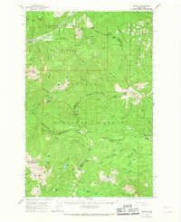
1962 Map of Lester
USGS Topo · Published 1968About this map
Lester stands as a primary outpost along the Northern Pacific railroad line in the early 1960s, serving as a critical point of access to the high mountain passes of the Cascades. The settlement is positioned near the Lester Airstrip and the Intake of the Green River Watershed (City of Tacoma), highlighting its role in regional infrastructure and resource management. The map details the complex intersection of four counties — King, Kittitas, Yakima, and Pierce — which meet amidst a landscape dominated by the Snoqualmie National Forest and Wenatchee National Forest.
Find a feature on this map
80 named features on this map. Tap any name to fly to it.
Don’t see what you’re looking for? This feature index may not catch every label — zoom into the map to look around manually.
Map Details
Editions of this 1962 Lester Map

Other maps of this area

1901 · Snoqualmie Pass
USGS Topo · 1:125,000

1902 · Mount Aix
USGS Topo · 1:125,000

1903 · Snoqualmie
USGS Topo · 1:125,000

1904 · Mt Aix
USGS Topo · 1:125,000

1913 · Cedar Lake
USGS Topo · 1:125,000

1924 · Mt Rainier
USGS Topo · 1:96,000

1928 · Mt Rainier
USGS Topo · 1:125,000

1950 · Yakima
USGS Topo · 1:250,000

1956 · Greenwater
USGS Topo · 1:62,500

1957 · Wenatchee
USGS Topo · 1:250,000