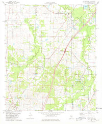
1981 Map of Letohatchee
USGS Topo · Published 1981About this map
Letohatchee serves as a primary hub in this portion of the Alabama Black Belt during the early 1980s, positioned where local routes converge near the Louisville and Nashville railroad line. The landscape is defined by the winding paths of Pintlalla Creek and Steep Creek, which dictate the placement of early settlements and agricultural boundaries. Evidence of long-standing community centers is visible in the numerous country churches and family burial grounds that dot the terrain, such as Bezziel Springs Ch, Tabernacle Ch, and the Gilbert Cem north of Tyson.
Find a feature on this map
29 named features on this map. Tap any name to fly to it.
Don’t see what you’re looking for? This feature index may not catch every label — zoom into the map to look around manually.
Map Details
Editions of this 1981 Letohatchee Map
2 editions found
Other maps of this area

1927 · Montgomery
USGS Topo · 1:48,000

1930 · Montgomery
USGS Topo · 1:62,500

1953 · Montgomery
USGS Topo · 1:250,000

1956 · Montgomery
USGS Topo · 1:250,000

1957 · Montgomery
USGS Topo · 1:250,000

1957 · Letohatchee
USGS Topo · 1:62,500

1957 · Autaugaville
USGS Topo · 1:62,500

1958 · Montgomery
USGS Topo · 1:62,500

1958 · Montgomery South
USGS Topo · 1:24,000

1975 · Autaugaville SE
USGS Topo · 1:24,000