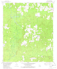
1981 Map of Leton
USGS Topo · Published 1982About this map
The Cotton Valley Gas and Oil Field dominates the western portion of this Webster Parish landscape, defined by an extensive network of access roads and a refinery near an Industrial Waste Pond. This industrial footprint contrasts with the rural character of settlements like Leton and Evergreen to the east. The terrain is defined by the winding course of Bayou Dorcheat and its various tributaries, including Wildcat Slough and Davis Slough. Genealogists will find several rural landmarks of interest, such as New Zion Ch, Old Union Ch, and the Hodge Cem. The southern edge of the sheet transitions into the protected woodlands of the Kisatchie National Forest, where smaller waterways like Flat Lick Creek and Canon Creek drain toward the bayou system.
Find a feature on this map
34 named features on this map. Tap any name to fly to it.
Don’t see what you’re looking for? This feature index may not catch every label — zoom into the map to look around manually.
Map Details
Editions of this 1981 Leton Map
This is the sole edition of this map. No revisions or reprints were ever made.
Other maps of this area

1922 · Sarepta
USGS Topo · 1:62,500

1924 · Sarepta
USGS Topo · 1:62,500

1947 · Minden
USGS Topo · 1:62,500

1949 · Minden
USGS Topo · 1:62,500

1949 · Gibsland
USGS Topo · 1:62,500

1950 · Gibsland
USGS Topo · 1:62,500

1952 · Homer
USGS Topo · 1:62,500

1955 · Shreveport
USGS Topo · 1:250,000

1956 · Shreveport
USGS Topo · 1:250,000

1956 · Sarepta
USGS Topo · 1:62,500