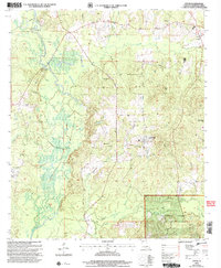
2003 Map of Leton
USGS Topo · Published 2005About this map
Kisatchie National Forest dominates the eastern half of this terrain in north Louisiana, where the land transitions from the low-lying wetlands of Bayou Dorcheat to higher timbered ridges like Bull Hill. The western portion of the map is defined by a complex network of waterways, including Wildcat Slough and Dough Valley Slough, which feed into the primary bayou system. This 2003 revision reveals a landscape shaped by both nature and industry, with an active gas field, a network of pipelines, and a refinery situated near an Industrial Waste Pond.
Find a feature on this map
30 named features on this map. Tap any name to fly to it.
Don’t see what you’re looking for? This feature index may not catch every label — zoom into the map to look around manually.
Map Details
Editions of this 2003 Leton Map
This is the sole edition of this map. No revisions or reprints were ever made.
Other maps of this area

1922 · Sarepta
USGS Topo · 1:62,500

1924 · Sarepta
USGS Topo · 1:62,500

1947 · Minden
USGS Topo · 1:62,500

1949 · Minden
USGS Topo · 1:62,500

1949 · Gibsland
USGS Topo · 1:62,500

1950 · Gibsland
USGS Topo · 1:62,500

1952 · Homer
USGS Topo · 1:62,500

1955 · Shreveport
USGS Topo · 1:250,000

1956 · Shreveport
USGS Topo · 1:250,000

1956 · Sarepta
USGS Topo · 1:62,500