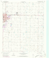
1965 Map of Levelland East
USGS Topo · Published 1981About this map
The growing community of Levelland serves as the focal point of this survey, which captures the city's eastern expansion across the West Texas High Plains. The landscape is a distinct blend of institutional growth and petroleum industry, evidenced by the presence of South Plains Jr College and numerous Oil Wells peppered throughout the surrounding countryside. Transportation and social infrastructure are firmly established by the Atchison Topeka and Santa Fe railroad running east toward Opdyke, alongside a dense network of local schools like Capitol Sch and Carver Sch. Mid-century leisure culture is also visible through the Drive-in Theater and the Levelland Country Club. On the western edge, the Municipal Airfield and a nearby Racetrack suggest a regional hub in development during the 1960s, while the Cem and St Michaels Sch & Ch provide key touchpoints for genealogists.
Find a feature on this map
36 named features on this map. Tap any name to fly to it.
Don’t see what you’re looking for? This feature index may not catch every label — zoom into the map to look around manually.
Map Details
Editions of this 1965 Levelland East Map
2 editions found
Other maps of this area

1954 · Brownfield
USGS Topo · 1:250,000

1957 · Meadow
USGS Topo · 1:62,500

1957 · Wolfforth
USGS Topo · 1:62,500

1958 · Brownfield
USGS Topo · 1:250,000

1962 · Brownfield
USGS Topo · 1:250,000

1964 · Whitharral
USGS Topo · 1:24,000

1965 · Levelland West
USGS Topo · 1:24,000

1965 · Sundown
USGS Topo · 1:24,000

1965 · Levelland East
USGS Topo · 1:24,000

1965 · Hester Ranch
USGS Topo · 1:24,000