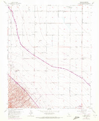
1956 Map of Levis
USGS Topo · Published 1972About this map
The California Aqueduct carves a diagonal path through this Fresno County landscape, marking the intersection of massive state water projects and established agricultural patterns. The survey, photorevised in 1971, captures the industrial infrastructure of the San Joaquin Valley, from the Oil Pumping Station at Levis to the numerous wells and pipelines servicing the central valley floor. To the southwest, the terrain transitions sharply where the Foot Hills and Ciervo Hills rise above the flatlands, drained by the Arroyo Ciervo.
Find a feature on this map
33 named features on this map. Tap any name to fly to it.
Don’t see what you’re looking for? This feature index may not catch every label — zoom into the map to look around manually.
Map Details
Editions of this 1956 Levis Map
3 editions found
Other maps of this area

1912 · Coalinga
USGS Topo · 1:125,000

1913 · Panoche
USGS Topo · 1:125,000

1915 · Priest Valley
USGS Topo · 1:125,000

1922 · Tufts Ranch
USGS Topo · 1:31,680

1922 · Chaney Ranch
USGS Topo · 1:31,680

1923 · Levis
USGS Topo · 1:31,680

1923 · Englebrecht Ranch
USGS Topo · 1:31,680

1923 · Monocline Ridge
USGS Topo · 1:31,680

1924 · Tranquillity
USGS Topo · 1:31,680

1931 · Mouth of Cantua Creek
USGS Topo · 1:31,680