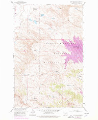
1958 Map of Lewis Reservoir
USGS Topo · Published 1978About this map
Fort Peck Lake dominates the eastern landscape of this Valley County region, its shoreline fingers reaching into the deep drainage system of the Charles M Russell National Wildlife Range. The map reveals an intricate network of water management and irrigation infrastructure throughout the interior coulees and ridges, highlighted by the Rentention Levees Experimental Area and the Willow Flat Diversion Dam. Dozens of small, family-named and numbered reservoirs like Lost McMenomey Reservoir, Langen Reservoir, and Berger Reservoir dot the landscape between South Fork Duck Creek and North Fork Duck Creek. This pattern of scattered reservoirs and levees underscores the vital role of water conservation in the Montana rangeland during the mid-20th century, where every coulee and creek was harnessed to support local livestock and wildlife.
Find a feature on this map
31 named features on this map. Tap any name to fly to it.
Don’t see what you’re looking for? This feature index may not catch every label — zoom into the map to look around manually.
Map Details
Editions of this 1958 Lewis Reservoir Map
3 editions found
Other maps of this area

1943 · Glasgow
USGS Topo · 1:125,000

1954 · Jordan
USGS Topo · 1:250,000

1954 · Glasgow
USGS Topo · 1:250,000

1956 · Jordan
USGS Topo · 1:250,000

1957 · Glasgow
USGS Topo · 1:250,000

1958 · Glasgow
USGS Topo · 1:250,000

1958 · Jordan
USGS Topo · 1:250,000

1958 · Miller Coulee
USGS Topo · 1:62,500

1958 · Collins Ranch
USGS Topo · 1:62,500

1958 · Lewis Reservoir
USGS Topo · 1:24,000