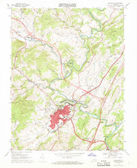
1967 Map of Lexington
USGS Topo · Published 1969About this map
Lexington serves as the focal point of this 1960s survey, illustrating the dense concentration of civic and educational institutions that define this Virginia community. The footprint of Washington & Lee University and the Virginia Military Institute dominate the northern part of the city, while the downtown core is clearly mapped with its Courthouse, City Hall, Library, and Post Office. Beyond the urban center, the landscape transitions into the river valleys of the Maury River and South River, where the rail corridors of the Chesapeake and Ohio weave through the terrain. Cultural and local history landmarks appear throughout the surrounding countryside, including the Old Monmouth Cem and New Monmouth Ch. Transportation infrastructure like the Landing Strip and a Drive-in Theater reflect mid-century rural development in Rockbridge County.
Find a feature on this map
66 named features on this map. Tap any name to fly to it.
Don’t see what you’re looking for? This feature index may not catch every label — zoom into the map to look around manually.
Map Details
Editions of this 1967 Lexington Map
4 editions found
Other maps of this area

1894 · Natural Bridge
USGS Topo · 1:125,000

1894 · Lexington
USGS Topo · 1:125,000

1894 · Natural Bridge
USGS Topo · 1:62,500

1907 · Natural Bridge Special
USGS Topo · 1:62,500

1932 · Lexington
USGS Topo · 1:48,000

1935 · Buena Vista
USGS Topo · 1:48,000

1937 · Lexington
USGS Topo · 1:62,500

1939 · Buena Vista
USGS Topo · 1:62,500

1940 · Buena Vista
USGS Topo · 1:62,500

1946 · Millboro
USGS Topo · 1:62,500