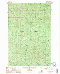
1989 Map of Liberty
USGS Topo · Published 1989About this map
Liberty and the surrounding high country of the Wenatchee National Forest are defined by a legacy of resource extraction and seasonal recreation. Situated in the Wenatchee Mountains, this late-twentieth-century landscape shows numerous prospect sites and strip mines along Williams Creek and Boulder Creek, reflecting the area's mining history. The importance of travel and tourism is evident at Blewett Pass and the Mineral Springs Resort, which serve as gateways to the drainage basins of Swauk Creek and the Teanaway River. Developed recreation is concentrated at sites like the Swauk Campground and Baker Creek Campground. The map preserves the complex topography of Swauk Ridge and Teanaway Ridge, where the borders of Kittitas and Chelan counties meet amidst a network of forest roads and creek-fed gulches.
Find a feature on this map
39 named features on this map. Tap any name to fly to it.
Don’t see what you’re looking for? This feature index may not catch every label — zoom into the map to look around manually.
Map Details
Editions of this 1989 Liberty Map
2 editions found
Other maps of this area

1897 · Mount Stuart
USGS Topo · 1:125,000

1902 · Mount Stuart
USGS Topo · 1:125,000

1957 · Wenatchee
USGS Topo · 1:250,000

1958 · Thorp
USGS Topo · 1:62,500

1958 · Cle Elum
USGS Topo · 1:62,500

1961 · Liberty
USGS Topo · 1:62,500

1961 · Mount Stuart
USGS Topo · 1:62,500

1975 · Wenatchee
USGS Topo · 1:100,000
1985 · Swauk Prairie
USGS Topo · 1:24,000
1985 · Reecer Canyon
USGS Topo · 1:24,000