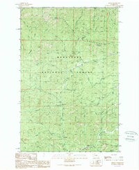
1989 Map of Liberty
USGS Topo · Published 1989About this map
Liberty sits at the base of the Wenatchee Mountains, serving as a central point for the mining and recreational activity that has long defined this part of the Wenatchee National Forest. This 1980s-era documentation highlights a landscape transitioning between its extraction roots and its role as a mountain getaway. Traces of industrial history are visible in the numerous labels for prospects, a Quarry, and Strip Mines concentrated near Williams Creek, while the presence of the Mineral Springs Resort and several campgrounds like Swauk Campground indicate the area's established appeal for visitors.
Find a feature on this map
45 named features on this map. Tap any name to fly to it.
Don’t see what you’re looking for? This feature index may not catch every label — zoom into the map to look around manually.
Map Details
Editions of this 1989 Liberty Map
2 editions found
Other maps of this area

1897 · Mount Stuart
USGS Topo · 1:125,000

1902 · Mount Stuart
USGS Topo · 1:125,000

1957 · Wenatchee
USGS Topo · 1:250,000

1958 · Thorp
USGS Topo · 1:62,500

1958 · Cle Elum
USGS Topo · 1:62,500

1961 · Liberty
USGS Topo · 1:62,500

1961 · Mount Stuart
USGS Topo · 1:62,500

1975 · Wenatchee
USGS Topo · 1:100,000
1985 · Swauk Prairie
USGS Topo · 1:24,000
1985 · Reecer Canyon
USGS Topo · 1:24,000