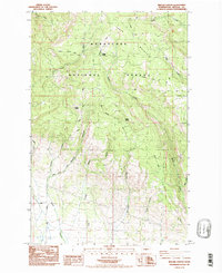
1985 Map of Reecer Canyon
USGS Topo · Published 1985About this map
Wenatchee National Forest covers much of this mid-1980s landscape, where the high terrain of Table Mountain transitions into a complex system of drainages and ridges. The map captures a high-elevation environment defined by its water sources and historical routes, including Garrison Spring, Barrel Spring, and the Teanaway Wilson Stock Trail. Evidence of seasonal or specialized activity is found at Riders Cabin, while the presence of a Steel Tower Trans Line and multiple power lines shows the encroachment of infrastructure into the forested highlands. Numerous canyons, such as First Canyon and Currier Canyon, define the western slopes, feeding into Reecer Creek. This survey reflects a period of forest management and early utility expansion in the Kittitas region, documenting the network of unimproved roads like Table Mountain Road and Ragan Way used for mountain access.
Find a feature on this map
27 named features on this map. Tap any name to fly to it.
Don’t see what you’re looking for? This feature index may not catch every label — zoom into the map to look around manually.
Map Details
Editions of this 1985 Reecer Canyon Map
2 editions found
Other maps of this area

1897 · Mount Stuart
USGS Topo · 1:125,000

1902 · Mount Stuart
USGS Topo · 1:125,000

1913 · Wenatchee
USGS Topo · 1:62,500

1915 · Wenatchee
USGS Topo · 1:62,500

1920 · Colockum Pass
USGS Topo · 1:125,000

1922 · Colockum Pass
USGS Topo · 1:125,000

1957 · Wenatchee
USGS Topo · 1:250,000

1958 · Thorp
USGS Topo · 1:24,000

1958 · Thorp
USGS Topo · 1:62,500
1958 · Ellensburg North
USGS Topo · 1:24,000