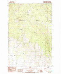
1985 Map of Reecer Canyon
USGS Topo · Published 1985About this map
Wenatchee National Forest dominates this mid-1980s landscape, where a series of deep north-south drainages define the rugged terrain of the eastern Cascades. The map documents a workspace of the high country, centered on the prominent Table Mountain and the headwaters of Reecer Creek. Life in these higher elevations is marked by isolated landmarks like Riders Cabin and vital water sources such as Garrison Spring and Barrel Spring. The presence of the Teanaway Wilson Stock Trail and various unnamed trails suggests a history of grazing and land management, while the Borrow Pit and Quarry indicate local extraction. To the south, the topography softens toward Lillard Hill, though the land remains cut by significant ravines including Robbins Canyon and Currier Canyon, illustrating the complex drainage system feeding into the Kittitas Valley.
Find a feature on this map
28 named features on this map. Tap any name to fly to it.
Don’t see what you’re looking for? This feature index may not catch every label — zoom into the map to look around manually.
Map Details
Editions of this 1985 Reecer Canyon Map
2 editions found
Other maps of this area

1897 · Mount Stuart
USGS Topo · 1:125,000

1902 · Mount Stuart
USGS Topo · 1:125,000

1913 · Wenatchee
USGS Topo · 1:62,500

1915 · Wenatchee
USGS Topo · 1:62,500

1920 · Colockum Pass
USGS Topo · 1:125,000

1922 · Colockum Pass
USGS Topo · 1:125,000

1957 · Wenatchee
USGS Topo · 1:250,000

1958 · Thorp
USGS Topo · 1:24,000

1958 · Thorp
USGS Topo · 1:62,500
1958 · Ellensburg North
USGS Topo · 1:24,000