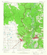
1955 Map of Liberty
USGS Topo · Published 1966About this map
The Trinity River snakes through a dense network of bayous and oxbow lakes, creating a complex wetland geography that defines the eastern edge of this mid-century survey. On higher ground, the settlements of Dayton and Liberty serve as the primary hubs, connected by the Old Spanish Trail and the Texas and New Orleans railroad. This era represents a significant period of petroleum extraction, with the extensive Hardin Oil Field and Martha Oil Field showing dozens of individual wells, tanks, and pipelines carved into the landscape.
Find a feature on this map
75 named features on this map. Tap any name to fly to it.
Don’t see what you’re looking for? This feature index may not catch every label — zoom into the map to look around manually.
Map Details
Editions of this 1955 Liberty Map
2 editions found

Other maps of this area

1916 · Crosby
USGS Topo · 1:24,000

1916 · Huffman
USGS Topo · 1:24,000

1919 · Crosby
USGS Topo · 1:31,680

1920 · Huffman
USGS Topo · 1:31,680

1943 · Liberty
USGS Topo · 1:125,000
1944 · Crosby
USGS Topo · 1:31,680

1950 · Houston
USGS Topo · 1:250,000
1954 · Crosby
USGS Topo · 1:24,000

1954 · Beaumont
USGS Topo · 1:250,000

1955 · Daisetta
USGS Topo · 1:62,500