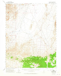
1963 Map of Lida Wash
USGS Topo · Published 1965About this map
Clayton Valley dominates the northern reaches of this mid-century Nevada landscape, where the flat expanse of the valley floor meets a complex of industrial and natural features. A large Settling Basin and an curiously named Alcatraz Island sit at the northern edge, indicating the specialized land use in this desert sink. Moving south, the terrain rises sharply into the Silver Peak Range and the Palmetto Mts, where high-altitude water sources like McNamara Spring and Birch Creek Spring supported local activity. The presence of the McNamara Mine and other unnamed Mines suggest the area's mineral importance, linked to the valley by a network of desert tracks including Coyote Road and Nivloc Road. This survey documents a quiet period of mining exploration and ranching outposts, such as Cox Camp, before modern shifts in regional industry.
Find a feature on this map
27 named features on this map. Tap any name to fly to it.
Don’t see what you’re looking for? This feature index may not catch every label — zoom into the map to look around manually.
Map Details
Editions of this 1963 Lida Wash Map
2 editions found
Other maps of this area

1898 · Silver Peak
USGS Topo · 1:125,000

1900 · Silver Peak
USGS Topo · 1:125,000

1908 · Lida
USGS Topo · 1:250,000

1913 · Lida
USGS Topo · 1:250,000

1945 · Goldfield
USGS Topo · 1:125,000

1954 · Goldfield
USGS Topo · 1:250,000

1955 · Goldfield
USGS Topo · 1:250,000

1957 · Magruder Mtn
USGS Topo · 1:62,500

1958 · Goldfield
USGS Topo · 1:250,000

1958 · Soldier Pass
USGS Topo · 1:62,500