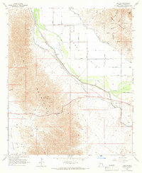
1965 Map of Ligurta
USGS Topo · Published 1966About this map
The Gila River valley in southwestern Arizona is dominated by an extensive network of irrigation infrastructure and historical transportation corridors. The Wellton-Mohawk Canal, Dome Canal, and Dome Main Canal provide the backbone for agricultural development within Dome Valley, where numerous pumping stations and siphons manage the desert water supply. These modern systems parallel the historic Butterfield Stage Route and the Southern Pacific railroad, tracing the same natural path through the basin that travelers have used for generations.
Find a feature on this map
47 named features on this map. Tap any name to fly to it.
Don’t see what you’re looking for? This feature index may not catch every label — zoom into the map to look around manually.
Map Details
Editions of this 1965 Ligurta Map
3 editions found
Other maps of this area

1926 · Fortuna
USGS Topo · 1:62,500

1926 · Wellton
USGS Topo · 1:62,500

1929 · Fortuna
USGS Topo · 1:62,500

1929 · Laguna
USGS Topo · 1:62,500

1929 · Wellton
USGS Topo · 1:62,500

1942 · Yuma
USGS Topo · 1:250,000

1943 · Laguna
USGS Topo · 1:62,500

1954 · El Centro
USGS Topo · 1:250,000

1955 · El Centro
USGS Topo · 1:250,000
1955 · Dome
USGS Topo · 1:24,000