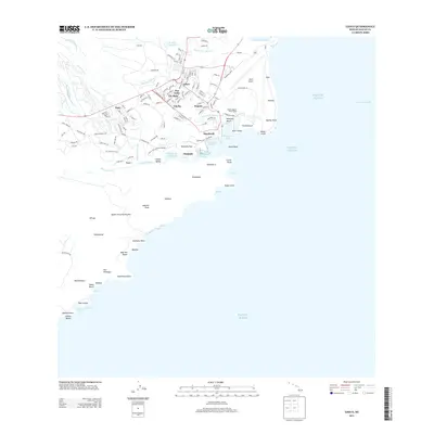
2013 Map of Lihue
USGS Topo · Published 2013About this map
The coastal gateway of Lihu'e serves as the focal point of this island landscape, where the urban center meets the natural protective boundaries of the Huleia Natl Wildlife Refuge. The map details a sophisticated network of waterways and maritime infrastructure, including Nawiliwili Harbor and the Nawiliwili Small Boat Harbor, which together facilitate the region's sea-based economy. To the south, the historic Menehune Fishpond lies along the Huleia Stream, representing traditional land use patterns adjacent to newer developments like the Kauai Lagoons Golf Course.
Find a feature on this map
138 named features on this map. Tap any name to fly to it.
Don’t see what you’re looking for? This feature index may not catch every label — zoom into the map to look around manually.
Map Details
Editions of this 2013 Lihue Map
This is the sole edition of this map. No revisions or reprints were ever made.
Other maps of this area

1954 · Kauai
USGS Topo · 1:250,000

1963 · Lihue
USGS Topo · 1:24,000

1963 · Kapaa
USGS Topo · 1:24,000

1963 · Koloa
USGS Topo · 1:24,000

1965 · Waialeale
USGS Topo · 1:24,000

1967 · Kauai
USGS Topo · 1:250,000

1970 · Kauai
USGS Topo · 1:250,000

1978 · Kapaa
USGS Topo · 1:24,000
1978 · Lihue
USGS Topo · 1:24,000
1978 · Koloa
USGS Topo · 1:24,000