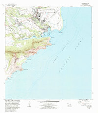
1983 Map of Lihue
USGS Topo · Published 1984About this map
Lihue and its surrounding coastal settlements are documented here during a period of significant regional development. The landscape is defined by the vital industrial and transport hub at Nawiliwili Bay, where the port meets the Lihue Airport. Inland, the map reveals the institutional core of the island, featuring the Kauai Community College, Wilcox Memorial Hospital, and the Immaculate Conception Sch.
Find a feature on this map
60 named features on this map. Tap any name to fly to it.
Don’t see what you’re looking for? This feature index may not catch every label — zoom into the map to look around manually.
Map Details
Editions of this 1983 Lihue Map
This is the sole edition of this map. No revisions or reprints were ever made.
Other maps of this area

1954 · Kauai
USGS Topo · 1:250,000

1963 · Lihue
USGS Topo · 1:24,000

1963 · Kapaa
USGS Topo · 1:24,000

1963 · Koloa
USGS Topo · 1:24,000

1965 · Waialeale
USGS Topo · 1:24,000

1967 · Kauai
USGS Topo · 1:250,000

1970 · Kauai
USGS Topo · 1:250,000

1978 · Kapaa
USGS Topo · 1:24,000
1978 · Lihue
USGS Topo · 1:24,000
1978 · Koloa
USGS Topo · 1:24,000