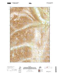
2019 Map of Lime Hills B-1 SE
USGS Topo · Published 2019About this map
Lake Clark National Park dominates this high-altitude landscape within the Kenai Peninsula Borough, where glacial-fed waters carve through the steep relief of the Alaska Range. The Chilligan River flows southward through the northeastern portion of the quadrangle, while the Igitna River moves across the southwestern sections. These drainage patterns define the geography of the park's interior, showing the natural transition of meltwater from the upper peaks toward the lake systems. The map detail highlights the complex wetland and hydrographic networks that support the region's ecosystem, preserved within the national park boundaries. Without roads or permanent settlements, the area remains a study in natural topographical evolution and protected wilderness.
Find a feature on this map
9 named features on this map. Tap any name to fly to it.
Don’t see what you’re looking for? This feature index may not catch every label — zoom into the map to look around manually.
Map Details
Editions of this 2019 Lime Hills B-1 SE Map
This is the sole edition of this map. No revisions or reprints were ever made.
Other maps of this area

1949 · Tyonek
USGS Topo · 1:250,000

1951 · Tyonek
USGS Topo · 1:250,000

1951 · Lime Hills
USGS Topo · 1:250,000

1958 · Tyonek B-8
USGS Topo · 1:63,360

1958 · Tyonek
USGS Topo · 1:250,000

1958 · Tyonek A-8
USGS Topo · 1:63,360

1958 · Lime Hills B-1
USGS Topo · 1:63,360
1958 · Lime Hills A-1
USGS Topo · 1:63,360

1958 · Lime Hills
USGS Topo · 1:250,000

1965 · Tyonek
USGS Topo · 1:250,000