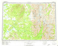
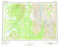
1958 Map of Lime Hills
USGS Topo · Published 1975About this map
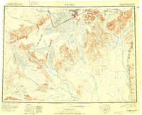
Lime Village sits as the primary settlement on this interior Alaskan map, positioned along the wide corridor of the Stony River. To the southwest, the Sparrevohn Air Force Station represents a critical Cold War-era military footprint in the remote wilderness. The eastern portion of the map is dominated by the massive peaks of the Alaska Range, featuring dramatic ice and rock formations like the Revelation Glacier, Tired Pup Glacier, and the distinct spire of The Tusk.
Find a feature on this map
107 named features on this map. Tap any name to fly to it.
Don’t see what you’re looking for? This feature index may not catch every label — zoom into the map to look around manually.
Map Details
Editions of this 1958 Lime Hills Map
3 editions found

Other maps of this area

1944 · Kenai
USGS Topo · 1:250,000

1946 · Lake Clark
USGS Topo · 1:250,000

1949 · Tyonek
USGS Topo · 1:250,000
1949 · McGrath
USGS Topo · 1:250,000

1950 · Kenai
USGS Topo · 1:250,000
1950 · Sleetmute
USGS Topo · 1:250,000

1950 · McGrath
USGS Topo · 1:250,000

1950 · Talkeetna
USGS Topo · 1:250,000

1950 · Taylor Mountains
USGS Topo · 1:250,000
1951 · Talkeetna
USGS Topo · 1:250,000