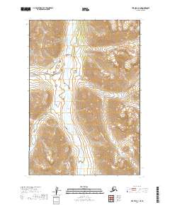
2019 Map of LIme Hills C-1 NE
USGS Topo · Published 2019About this map
The Styx River flows through this interior landscape within the Lime Hills region of the Bethel Census Area. This 2019 survey, based on U.S. Geological Survey data and SPOT imagery from 2010, details a wilderness area defined by significant relief and glacial-fed drainage patterns. The map provides precise Public Land Survey System (PLSS) grid alignments, showing the meeting of township boundaries t19n r22w, t19n r21w, t18n r22w, and t18n r21w. This specific sector remains undeveloped, lacking roads or named settlements, offering a detailed look at the hydrography of the Styx River basin before any modern human footprint. It is a vital document for those studying the physical geography of the Alaska Range foothills or the specific hydrology of this drainage system.
Find a feature on this map
5 named features on this map. Tap any name to fly to it.
Don’t see what you’re looking for? This feature index may not catch every label — zoom into the map to look around manually.
Map Details
Editions of this 2019 LIme Hills C-1 NE Map
This is the sole edition of this map. No revisions or reprints were ever made.
Other maps of this area

1949 · Tyonek
USGS Topo · 1:250,000

1951 · Tyonek
USGS Topo · 1:250,000

1951 · Lime Hills
USGS Topo · 1:250,000

1958 · Tyonek C-8
USGS Topo · 1:63,360

1958 · Tyonek D-8
USGS Topo · 1:63,360

1958 · Tyonek
USGS Topo · 1:250,000
1958 · Lime Hills D-1
USGS Topo · 1:63,360

1958 · Lime Hills C-1
USGS Topo · 1:63,360

1958 · Lime Hills
USGS Topo · 1:250,000

1965 · Tyonek
USGS Topo · 1:250,000